Friday, October 14, 2011

And Now I Have AIS

Warning: Technical sailing and navigating info!

When I started "messing" around in boats over 40 years ago, we did not have much to navigate with. My early boats had a compass and I carried paper charts and simple parallel rules and dividers for plotting courses. I cruised with these basic items and even crossed the Strait of Juan de Fuca in dense fog several times. It was the way we did things then. If anything I became good at plotting my course and finding my way in inclement weather and at night.

It was not until I bought my 30 foot sailboat "Good News" in 1977 did I start installing more navigation equipment. In addition to a compass, I now had a knotmeter to indicate how fast I was going and a depth sounder. The depth sounders of that era were referred to as "flashers". The unit had a disc rotated by an electric motor. On the disc was a neon light that would flash along a scale to indicate the depth. My depth sounder was a 0-100 foot unit, but if conditions were good, the flashing light could go around the dial multiple times. I once saw it go around six times indicating 600 feet.

As time went on and electronics became cheaper and more compact. I bought my first VHF radio around 1980. This allowed me to call for help, communicate with other boats and shore stations and monitor weather broadcasts. About this time I also bought a radio direction finder. This was a receiver with a rotating antenna. You could use this to receive a bearing to dedicated navigational beacons or commercial radio stations. The ideal was to get three bearings and plot them on a chart to indicate the boats position. In reality we often were happy with a single bearing line as a second opinion of our already predicted position.

By the mid 1980's, LORAN-C became popular. LORAN stood for Long Range Aid to Navigation. LORAN had been around since World War II and was mainly a aircraft navigation system. The "C" version was developed in the mid 1950's. LORAN uses shore radio transmitters with a "master" station and several "slave" stations. With the signals from the stations, the receivers derived a set of numbers referred to as TD's or time delays. Charts were overprinted with lines of TD's and where the TD's cross was the position of the vessel. Somewhat cumbersome, but as time went on and thanks to modern microprocessors, the LORAN-C receivers would derive the TD's to Latitude and Longitude. In addition, the receivers could also provide navigation and steering information such as: SOG(speed over ground), COG(course over ground), BTW(bearing to waypoint), DTW(distance to waypoint) and CTE(cross track error). Most units would only display "numbers", but more sophisticated, very expensive units were chartplotters and could display the position directly on a digital chart.

I purchased a Sitex LORAN unit in 1987. I liked it. After inputting waypoints to go to, it would direct me very accurately. I travelled many miles in foggy conditions, across open water and at night and always found my to my destination. Some strange things could occur with LORAN. Since the signal was a ground wave, in narrow mountainous areas, the signal was disrupted and I sometimes received strange results. Also LORAN only functioned about 200 miles offshore and some areas like south east Alaska had spotty coverage.

But LORAN soon was overtaken by GPS(Global Position System). As the name implies GPS works all over the globe. It receives signals from a constellation of satellites in synchronous orbit. I bough a Magellan handheld unit in the mid 1990's and later a Garmin mounted unit. These units were just "number" units like my LORAN and produced similar outputs as the LORAN. I still liked the LORAN and used it the most.

In 1999, I bought "Great White". Shortly after I bought "Great White", I purchased a Garmin 180 chartplotter. Now this was a big improvement! Even though it was a black/grey screen, it provided enough information to be able to navigate some with it. I slaved the GPS to the autopilot and it could steer to a waypoint better than I could. Later I bought a Garmin 182C chartplotter. The "C" stood for color. Now I had something that was easier to look at! I also started sending the output from the GPS to a laptop with a simple navigation program installed.

I first heard about AIS about 1994. AIS stands for Automatic Identification System. This is a system that transmits a vessels identification, speed, course and characteristics over the VHF radio. The AIS transponder receives its data from the GPS. Commercial vessels and ships are required to have an AIS. The other part of the AIS is a receiver. The receiver can either display the data it receives or send the data to a compatible display, GPS chartplotter or computer chartplotter program. In addition, the receiver can calculate the CPA (closest point of approach) and TCPA (time of closest point of approach) between the two vessels. A lot of AIS systems are still very expensive. A few years ago a spirited debate started on the sailing forums about the use of AIS. Some newer sailors were vocal about it being essential for safety and others like myself that felt that it was a "nice to have" that would have to wait until other expensive upgrades were completed. Also, my chartplotter was too old to support AIS. So I would have to come up with a new GPS or chartplotter software.

But last year at the boat show, I found a VHF radio that had an installed AIS receiver. Very cool and not too expensive. I was looking for a better VHF radio anyway. This radio had a small display that would show the CPA and TCPA from the approaching vessel. It is hard to read the numbers on the small display, but it was better than nothing. An alarm can be set to warn of close encounters. It has been useful already.

A few weeks ago a neighboring boater gave me a Garmin 498 Chartplotter. He could not get it to acquire satellites. I did not hold out much hope that it would work for me and sure enough, it would not acquire satellites with my antenna either. So I did some research and found that it could be reset. So I reset the system and it worked! This GPS is newer than my existing Garmin and it appeared that it was AIS compatible. So, I started investigating how to use it. First I found that it only had one "port". That meant that it could not send data at one baud rate and receive AIS info at another high speed baud rate. I could get a multiplexer that might make it work, but again that was expensive. So I thought that maybe I could use it only for an AIS receiver. I would still need an antenna for it. I finally gave up for the moment.

I then started looking into a new chartplotter software for the laptop. On the Van Isle Race last summer, the navigator was using a program called Open CPN(chartplotter navigator). This is a free navigating/charting program. And it is compatible with AIS. So I downloaded it, installed it on the nav laptop and started using it. I stumbled around and determined that it would do most of what I wanted. I then bought a couple of serial to USB converters, a hub and a serial cable and wired it up to the AIS. It worked! I had to mess with some configurations, but after after a few hours of experience with it, it seems stable and I have figured out the operation.

So, now that I have a graphical display of AIS info on the computer screen, how will I use it? After the newness wears off, I can see myself using it for a double check of crossing vessels. I usually check crossing vessels by taking bearings. In inclement weather and at night, I can see that it could work well to check for who is around. But I know that it is not the tell all. Already I can see targets disappear at times. Also could be used in racing. One of my competitors has a transponder. If he continues to use it, I can plot him and tell if he is getting closer! Wouldn't that be cool!

Here are a couple of websites that track vessel positions with AIS:
 http://marinetraffic.com/ais/
http://ais3.siitech.com/VTSLite/AView.aspx


A screen shot of Open CPN with the AIS function turned on and an example of the AIS screens available. The yellow targets are "unknowns". These have info on course, speed, CPA and TCPA but do not identify the vessel. Green targets contain information on the vessel. Red targets have CPA's that fall within the CPA range I have set for alerting for an approaching vessel. A list of target information can called up as well as individual vessel info that can be obtained by placing the cursor over a target. The ferry "Walla Walla" is passing through Rich Passage. It's course passes close to my position even though it is a few miles away. The yellow square near its location gives it's basic info and the CPA and TCPA. The "AIS Target Query" shows the full data on the "Walla Walla" and the "AIS Target List" lists all the AIS target within the range I set(21 miles).

Monday, October 10, 2011

Fallout In The Gorge

This weekend was a good opportunity to head to the Columbia River Gorge for some hiking around some of the falls that line the Oregon side of the gorge.

I met a friend from Portland and hiked up the trail past Wakeena Falls to the headwaters of the stream at Wakeena Springs. This was a strenuous climb up the side of the gorge past numerous falls and along the creek.

At the springs, I headed east and descended down the creek that feeds Multnomah Falls. Again it was very scenic with many falls and rapids in the creek.

Once I reached the lookout at the top of Multnomah Falls, I was in tourist territory. The trail is paved and was crowded with tourists from the parking lot below.

Sunday was rainy, so there was no more hiking. I went to the Woodburn Outlet Mall and wandered around and bought some shoes. Friday on the drive south, I had stopped at the outlet stores at Centralia and bought some kitchen utensils and some new sailing raingear at the Helly Hansen store. It was an expensive weekend!


 Wakeena Falls
 The view of the Gorge from just above Wakeena Falls


 Looking at the river from the top of Multnomah Falls
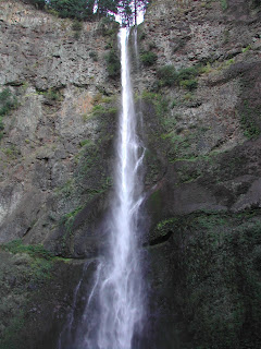
 Upper part of Multnomah Falls
 The tourist view of Multnomah Falls from just above the parking lot.
View of the Columbia River from the Vista House.

Tuesday, October 4, 2011

The Great Bronco Engine Transplant- Post Shakedown Availability

When I worked, I usually worked on designing systems for ships that had been in service for many years. But during a few years, I actually was lead on a class of new ships.  After these ships were completed, tested, turned over to the crew and operated for about a year, they went into a shipyard for a period called a Post Shakedown Availability(PSA). During this time, maintenance, warranty and upgrade work was performed. This is similar to what went on with the Bronco over the last month.


After almost 3000 miles of operation after installing the V8 engine in the Bronco, several items needed attention. The most pressing item was a leaky radiator. I contacted the manufacturer and they said that they would warranty the radiator, but they needed it sent to them for evaluation. So following the last Cruise at Sharis Restaurant a month ago, I removed the radiator and shipped it to Advance Adapters in California. This seemed like a good time to accomplish some maintenance and some upgrades. A partial list is as follows:

Replace oil filter hoses with stainless steel braided hoses.

Install new hose clamps on the braided hoses.

Install a thermal sleeve around the fuel line where it passes close to the drivers side header.

Find the source of a small transmission leak.

Replace engine oil pan drain plug gaskets with ones that don't leak.

Change oil.

Touch up engine paint.

While waiting for the new radiator, most of the list of work went pretty fast. Finally the radiator arrive last night and I installed it along with a new mounting design. Once again, the Bronco is operational. The PSA has been completed.
Prior to the PSA, I also bought some different wheels for the Bronco. These are aluminum wheels that were the optional wheels when the Bronco was new. I purchased five, four on the ground and one for the spare tire.

Monday, October 3, 2011

Foulweather Bluff Race-Oct 1st.

Saturday, we raced "Great White" in the Foulweather Bluff Race sponsored by Edmonds Corinthian Yacht Club. This race has both short and long courses. We race the long course from Edmonds to the Foulweather Bluff Buoy, to the Schatchet Head buoy and back to the finish north of Edmonds. We race the long course unless the winds are light and the Race Committee sends us on a short course to a temporary buoy off Pilot Point and then to the Schatchet Head buoy and then to the finish. That is what happened this year.

We raced in Class 7, a class made up of ourselves, two other J35's, a C&C115, a C&C37/40, a Dehler 39 and a 40foot Peterson 40. The handicap range was only 3 secs a mile with the J35's, C&C115 and Peterson  rated fastest at 72. The C&C37/40 and Dehler 39 are rated slower at 75, but they are much larger boats and have a higher speed potential. "Reign Maker"the C&C37/40 has a huge rig and is a great light air threat.

We started the race a bit late. We had to luff a couple of boats and got clear air. The first leg was a light air spinnaker reach. I concentrated on sailing to my target speeds. "Elusive"(C&C115) tried to luff us up and would not let us by, so when a faster boat that started behind us came by, I got on their stern and let them do our dirty work and take "Elusive's" air. As we neared the Kitsap shore, we continued sailing to our target speeds downwind and with the favorable current, we soon closed on the Pilot Point buoy.

When we got to the first mark we were just behind "The Boss" (J35). We changed to the No. 1 jib and had a close reach to the Schatchet Head buoy. With the strong, still ebbing current, we had to be aware of our course over ground(COG) to avoid being swept to the left of the buoy. We played that leg well. "Elusive" went way high and lost grond to us. We gained some on "The Boss".

After rounding the Schatchet Head buoy, "The Boss" got stuck in the bad air behind the boats ahead. We made a short hitch to the right to clear our air and gained on "The Boss". "The Boss" pinched to clear their air and fell in about 300 yards behind us.

A couple of miles from the finish, it looked like we would not make the finish line and the boats to weather seemed to have better wind, so I called for a short tack to the right.  No sooner did we tack back toward the finish when the wind lifted. We had overstood the finish and "The Boss" made the finish ahead of us without having to tack. They got first and we were second. I knew better! YOU ALWAYS STAY BETWEEN THE MARK AND THE BOAT BEHIND!

At least we finished well ahead of the rest of the boats behind. We usually struggle against the larger C&C115, but they finished well behind us in third.
It was still a good race and we had great crew work. Thanks to Kathleen, Walter and Jim.

Results here: http://cycedmonds.org/
Our track for the day. The course went in a clockwise direction.

Saturday, September 24, 2011

Bad Is Good

The third Saturday of September each year is BAD at the Brownsville Marina. BAD stands for "Brownsville Appreciation Day". This year was "BAD VII". The Port of Brownsville holds a "block party" for the Brownsville Community. There is a classic car show, historic military vehicle show, boat rides. barbecue and sort of a farmers market. The port's proceeds from the event goes back into the community.

To avoid the parking problems, I rode the bicycle to the marina. The upper parking lot was filled with cars. Like I am learning from attending these car shows, the shiniest, most accurately restored isn't always the most interesting. There were lots of cool conversions and a Bronco rat road that was really well done. I probably would have taken my Bronco II conversion except I have not yet received a warrantied radiator back from the manufacturer.

The Military vehicle display was well done with many old historic vehicles.

There seemed to be a good turnout. The weather was very warm and sunny for a early fall day.

 A nice stock late sixties Barracuda.
 A nice stock late sixties Barracuda.
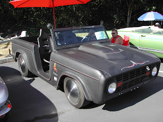
 A 67 Bronco "rat rod". Two wheel drive, Chevy 327 V8, Camaro front suspension. And a very nice but un-rat rod looking flat black paint job.
 Some of the cars on the grassy area above the upper parking lot.
 Some of the cars on the grassy area above the upper parking lot.
 More cars in the upper parking lot.
 Part of the Military vehicle display. The vehicle on the left is a half track with a 50 cal machine gun on the front and a 30 cal on the back. Both demilitarized of course!
The vendors along the shoreline.

Friday, September 23, 2011

An Interesting Week In The Life Of Dan

Warning! This blog entry contains information on several subjects. If you are looking for something specific like sailing or cycling, you may have to read through some uninteresting subjects to get there. You have been warned!

The last week has been interesting with some trials along the way. Where to begin? Ok, a few weeks ago, I developed a toothache. It seemed like a molar that had had a crown installed three years ago was developing cold/hot sensitivity. A couple Facebook friends encouraged me to see the dentist ahead of my normal appointment in Oct. Sure enough, the dentist did not like what he saw and sent me to the Endodontist(dentist that specializes in root canals). So, on Friday I walked into the office at 0720 and walked out at about 0845 with a numb mouth and a much lighter checkbook. I went home and slept most of the morning. BUT, the tooth did not stop hurting as promised. I feared that another adjacent tooth was acting up. It was really tiring to put up with the pain. So today at 0720, I got back into the Endodontist and told him my sad story. He checked the teeth with cold and there was no sensation. What he did find was that the filling that he filled the hole in my tooth with was sitting high, so he ground some off. Now the pressure is gone and my cold fruit smoothie is actually soothing!

So if the root canal wasn't enough financial stress, some boat gear is acting up. The hydraulic cylinder that controls the tension in some rigging that holds the mast up started leaking around the seal. I did some research and also with some advice from an acquaintance that runs a sailboat rigging company, I found that "sure, any hydraulic shop can overhaul them. They just use standard seals". So I took the cylinder to the only local hydraulic shop for overhaul. They said that they could get on it in a few days, but after eight days I called them on Thursday. They said that they would get on it that afternoon. That afternoon I got a call. They could not get it apart. The threads have galled. So with a race pending next weekend, I retrieved it and reinstalled it on the boat tonight. Hopefully it won't leak to much. After the race, I will probably send it to a "Authorized repair facility". And if they can't repair it, then I will price out a new one, OUCH!

If things were not going strange enough, last night, I got hit with malware on the computer. I was searching for some transmission drawings on the internet and hit a site that started trying to scan my computer for errors, trying to sell me data recovery software and showed all kinds of warnings. I could not close it out. I performed a virus scan and a hard drive scan. The scans made it appear that all my files were there, but I could not find anything! Most of the night, the scans ran but this morning it was no better. After returning from the dentist, I had a thought and ran a "System Restore" to a time before the event occurred. Sure enough the computer was restored to the configuration from the previous day. The malware was gone and all my files are back. The only thing missing is my Favorites on my browser. I need to fiqure out if those can be reloaded. I am happy this worked, I thought I was going to have to take the computer somewhere and pay to get it fixed.

So, while the computer was restoring this morning, I decided to take a bicycle ride. Two things I was wanting to try: some different wheels and the new pavement on Illahee Rd from Sylvan Way to Ocean View Road. A few years ago I bought a wheelset from Ebay. It is a nice set of wheels (Mavic Open Pro with Campy hubs) that are very light and showed no wear when I bought them. I probably only put about 100 miles on them with some old tires and zero miles since I installed new tires. The wheels I have been using on the white bike are Mavic CXP33's with Campy hubs. They are a semi aero wheel. I also bought that wheelset on Ebay and have put quite a few miles on them. Another cyclist had broken a wheel and I offered to loan him the Open Pro wheelset. He did not accept the offer, so I decided to try them out myself. I started out for a 21 mile ride to Keyport and back. Sure enough, the new pavement was smooth and fast. After about five miles, the bike got hard to peddle and soon I could not peddle at all. What is going on? I coasted to the side of the road and got off. It did not take me long to see that the retainer that screws into the end of the hub to hold on the rear cassette cogs had come loose and was jammed against the rear frame dropout. I removed the wheel and tightened the retainer by hand. Since I did not have the appropriate tool, I returned home to repair the bike. After tightening the ring with the special tools and after lunch, I once again set off on my 21 mile ride, this time without incident. The replacement wheelset has higher gearing(11 X 23 rear cogset) than my other wheelset, so the riding was more interesting than normal But the new wheels are light and roll easy and smooth and the total mileage for the day was 32miles with two climbs up the hill from Illahee to Sylvan Way.

Now if I only had the new radiator for the Bronco...... It has been two and a half weeks sent I sent the radiator in for warranty!
Tightening the retainer with the special driver, chain whip to hold the cogs and yes, a crescent wrench!

Sunday, September 11, 2011

Triple Sound Sailing Championship 9-11-2011

Today was the Triple Sound Sailing Championship(TSSC) in Seattle. This the final race of a three race shorthanded racing series. The first two races were the Race To The Straits(first weekend in May) and the Down The Sound Race(first race in August). The TSSC differs from the other two races in that it is a 13.89NM buoy race instead of a two day pursuit race like the other two were. All three of the races are sponsored by Sloop Tavern Yacht Club.

This race starts at Shilshole Marina, heads north to a club buoy at Spring Beach, south to the West Point nnavigation buoy,  north again to the Meadow Point navigation buoy, south again to a mooring buoy south of Shilshole and return to the start/finish line.

The wind was great at about 12 knots. I made a great start in front of the rest of the boats in my class. The beat was fast. Unfortunately, the local boats knew these waters better and tacked early for the first mark. I overstood the mark some. The rounding of the mark was crowded. I headed south and set the spinnaker. It was not a great effort.

The run was pretty uneventful until I got to the leeward mark. By now, the current was flooding and I waited too long before taking the spinnaker down and was swept past the mark. At least I was not the only one!

For the next beat, I worked along the Shilshole breakwater to avoid the current. I rounded the Meadow Point buoy and tried to set the spinnaker again. This time it was twisted and took some effort to get squared away. But as I neared the next leeward mark, I performed a smooth takedown and did not get swept past the mark. It was a short beat to the finish.

I probably placed in the middle of my 7 boat class today, but with a good showing in the previous two races, I should have won the singlehanded division.
 Boats getting ready to start.
 One of the earlier classes starting.
 On the first beat heading toward the Spring Beach buoy.
 On the first run.
My course for the day. The overlapping laps makes this confusing to look at.