Monday, June 29, 2009

Brownsville Race WSSA #7

Saturday was the 7th and final race of the West Sound Sailing Association(WSSA) series. This race was started at Brownsville, my home marina. It consisted of three laps: one to the day mark in Agate Pass near Point Bolin, to University Point, then to the start/finish line. The second lap went to a temp buoy at Battle Point, to University Point and the start/finish line again. The third lap was a repeat of the first. The race was a total of 18.95 nautical miles but could be shortened at the start/finish line at any of the laps.

The winds were light(3-4 knots) from the NW. The direction was really unusual for this area. Usually the wind is more N to NE. On Great White(J35), we got a good, but somewhat late start. We started to leeward of Dulcinea(J105) who was barging and we squeezed them outside the pin. Sweet Spot(J35) came right behind us and kept Dulcinea out of the starting area forcing them to circle around. Tantalus(Express 37) started at the other end of the line, but no earlier than us. We had clear air and tacked to port toward Bainbridge Island. As I said, the wind was unusually far toward the west and we sailed one tack to Arrow Point. Normally with a northerly, we cannot get around Battle Point without tacking. We put more distance on the rest of the fleet. Near Arrow Point we tacked toward the middle of Agate Pass as did Sweet Spot. Some boats thought that was a mistake. A strong ebb was flowing and I was concerned about getting swept past the mark. We stayed in the middle of the pass and upstream of the day mark at Pt Bolin. Some boats stayed adamntly on the right side and my hope was that the wind would die for awhile and let them get flushed past the mark. Reign Maker(C&C37XL) stayed on the Bainbridge Island shore and gained on us. At first it looked like they had passed us, but when they crossed Agate Pass, they were swept north and way overstood the mark. They were forced to sail downwind against the current.

We rounded first just ahead of Reign Maker. We jibeset onto starboard, but after Sweet Spot did a bear away set and headed left, we jibed to port and headed left. Sweet Spot got ahead of us and then the wind switched SW, so we went to the jib for a while and caught up to Sweet Spot. As we approached Battle Pt, the wind filled in from the N and we set spinakers again. We jibed to starboard looking for a little bit better wind(not the best idea), but jibed back to port to sail along the Bainbridge Island shore. The wind started getting spotty near University Point. We could not find a racing buoy set near University Point, so followed Sweet Spot around a mooring buoy. This met the definition of the mark: P-Buoy off University Point.

Sweet Spot was able to close reach to the start/finish line at the marina. We had to tack once. At the finish the crew of Sweet Spot was able to convince the RC that the mark was missing and the race was shortened. At least it was not thrown out and all the boats behind us rounded the mooring buoy(later Sweet Spot found the race buoy about 2 miles south near Illahee). The wind at the finish had risen to around 7 knots, so at least one more lap could have been completed.

In class, Sweet Spot was first. Dulcinea finshed close enough to us to correct on us by about 39seconds. Overall, Egress (Hotfoot27), a division II boat finished close enough to win 1st overall.

Our crew of Peg, Curt, Bob and Brendan did a great job and we had no sail handling errors. Bob and Brendan were from Tantrum II(Schock 35). Bob did not race Tantrum II because he was short of crew and came over to fill in for some of my missing crew.

For overall series results:

Egress 18 points- First Place
Falcon(Cal 9.2) 18 points- Second Place(after tie breaking process)
Great White (J35) 19 points- Third Place

The series was really tight this year. I was glad to see a division II boat win the series after many years of dominance by division I boats. Steve on Egress sailed a great series. Bryan with Falcon was leading the series up to the last race. In fact any one of four boats(Great White, Emerald Lady(Catalina27), Falcon or Egress) could have taken the series with a good showing in the last race.

Complete results can be found here:

http://kitsapsailing.com/wssa.html


Light winds after the start. Reign Maker behind us.

Light air spinaker reach. Reign Maker still behind us. Curt trimming the spinaker.

Our course for the day.

Friday, June 19, 2009

Ride Around The Olympic Peninsula-Part 4

While eating breakfast in Forks, I started thinking. My next scheduled camp was going to be Sol Duc Campground. I did plan on some short hikes there. BUT, it was only 35mile north and then from there I would be retracing my route home. So, after consulting Ms. Tom Tom again, I decided to head south, find another campground and when I head home on Thursday, I would have completed a loop around Olympic Peninsula. I decided my next destination would be Pacific Beach State Park.

As soon as I left Forks, the rain started. Or maybe it was heavy mist. I don't know, but it did not stop until I got to Pacific Beach, about 95 miles. The road looked slick and I was very cautious on the many curves on the road down the coast. I made a short rest stop at Kalaloch.

I found a camping spot at Pacific Beach. Again, there were lots of vacancies. The sun finally came out giving me a chance to dry my leathers. I played tourist. Wandered uptown and to the Navy camp to see if I would like it better(not). The beach was right at park so I went onto the sand and flew my stunt kite for a while.

In the morning, I packed up early and road the 20 miles or so to Ocean Shores for breakfast. I rode to the end of the beach and then started home. It was overcast, but at least there was no rain.

On the way home, I took a side trip at Satsop to ride up to the unfinished Nuclear Powerplants. The area is now an industrial park and the road goes right by the cooling towers and unfinished containment buildings. I understood that all the steam plant equipment was sold to a company in Japan. The equipment building is now a facility where tanks(you know, oil, water, etc.) are fabricated.

The rest of the ride home went well and I was home by 1210. I had plenty of time to rest up and get to Port Orchard for the Thursday night sailboat race. I crewed on "Tantrum II". We won. Unfortunatly while I was gone, my DSL modem died and I just got it replaced tonight.

Total mileage for the trip: 495.1 miles

Beach and lagoon at Kalaloch.

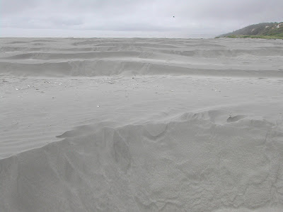
Mini sand dunes at Pacific Beach.

The North Jetty of Grays Harbor at Ocean Shores. Pacific Ocean on the right, Grays Harbor bar on the left.

Ride Around The Olympic Peninsula-Part 3

As I said earlier, my intent was to camp two nights at Lake Ozette. But I had been consulting Ms. Tom Tom(the onboard GPS) and started looking at more options for the second night. I decided that after the hike, I would have time to pack up and go somewhere else for the night. I decided to go farther south to Mora Campground on the north shore of the Quillayute River. It is also an Olympic National Park Campground.

It is only about 65miles from Lake Ozette to Mora, so I was there in about 2 hours. Once again, the campground was mostly empty, so I had no problem finding a nice campsite along the river. Later I rode the additional 2miles to Rialto Beach. I was there for only a few minutes when the rain started, so I retreated to the camp and got under cover for a while. The rain was light and quit in the early evening. It did get quite cold thru the night and my light weight sleeping bag was marginal for keeping me warm enough through.

The next morning, I rode to La Push on the south shore of the Quillayute River at the entrance to the ocean. It has probably been close to 20 years since I have been there and was pleased to see that the town has changed a lot for the good over the years. I was glad to see a newer RV park/hotel complex that looked nice. I had stayed at the previous hotel and it was less than desirable.

I rode back to Forks for breakfast. Interesting, Forks was a setting for a movie about vampires(Twilight?). The town is now a destination for fans of the movie. It was funny when entering the town to see people getting their pictures taken at the town's sign.

Rialto Beach looking north.

Rialto Beach looking south at James Island at the entrance of the Quillayute River. A few years ago a Coast Guards man lost his life when his boat was overwhelmed by storm seas and washed overboard. A Navy officer got into trouble trying to deliver his sailboat to Bremerton in the middle of the winter. The Coast Guard went out to assist him and at least one did not come back. One young seaman did ride the boat ashore onto James Island.

Driftwood on Rialto Beach.

Ride Around The Olympic Peninsula- Part 2- Cape Alava Trail Hike

On tuesday, my plan was to do the hike from Lake Ozette to the ocean, along the beach and back to Lake Ozette. Each leg of the hike is about 3 miles, forming a triangle. I was up early and was on the trail by 0700. It was cool and overcast when I started out, but warmed up when I arrived at the beach. I chose to hike the southern portion first to Sand Point. This trail through the rain forest is really an easy hike. It is fairly level and is mostly cedar boardwalks. It can be slick when wet.

From Sand Point, I hiked north toward Cape Alava.The tide was out far enough that there was no problem getting around the headlands that are awash at high tide. This part of the hike is a combination of sand, gravel, rocks, driftwood, fallen trees and seaweed. This makes for tiring hiking and vigilance is in order to avoid falling on some of the terrain.

From Cape Alava I hiked inland back to Lake Ozette and camp. This trail has more elevation change then the southern trail. It also passes through some meadows that were cleared by the early homesteaders. When I first hike this trail with my family in the early 60's, there was remains of the old home at Ahlstrom's prairie. I could have probably still found the remains, but did not feel like bushwacking through the brush.

I was back to my camp by 1100.

The route of the trail.

The boardwalk. This is how a great majority of the trail is built.

The rocky shoreline.

Interesting hole through the rock!

And another pic of the hole.

Ride Around The Olympic Peninsula-Part 1

This week I decided to take a motorcycle trip. There was a few more days of dry weather predicted before the rain was suppose to start. Still a chance of getting wet as the rain was suppose to start a day earlier on the coast. This was planned to be a ride to Lake Ozette, camp out one night, hike the 9.3 mile loop to the ocean, camp out another night at Lake Ozette, ride to Sol Duc Campground in the Olympics, camp out another night and then come home.

On Monday, I got underway around 0730 and rode across the Hood Canal Floating bridge and northwest on highway 104. This took me through Sequim and Port Angeles. It was a nice day for a ride. Clear, but a little cool, but the heated grips kept my hands toasty warm!

After Port Angeles, I exited right and rode the old highway through Joyce to Clallam Bay and Sekiu. This road was rough and winding. Since I am not much of a motorcyclist(I only own a motorcycle), I took it easy on the corners. I stopped at Salt Creek Campground for a short rest. Thought about stopping to camp. It was nearly empty.

The last time I went to Lake Ozette, the road from Sekiu to Lake Ozette was gravel for the last several miles. It is paved all the way now, but is still winding and rough.

The campground was nearly empty, so I picked out one of the 15 sites and set up camp. It has been quite a few years since I have camped there. It is in a lot nicer condition than what I remembered, although it is still pretty primative. The evening was pleasant and once during the night, the clouds cleared and the stars were spectacular.

Salt Creek Campground, looking over Crescent Bay and out the Strait of Juan de Fuca.

My camp at Lake Ozette Campground, Olympic National Park.

Saturday, June 13, 2009

And yet another nice day for a ride!

Since we are into a record setting period of days without rain, I thought this would be another good day to go for long bicycle ride. The local cycling club was leaving on a ride from Poulsbo to Port Ludlow. They were leaving at 0900, so by leaving from my home, I was giving them a big headstart. I had no idea if I would catch them.

I got underway at 0849 and rode north through Brownsville, Poulsbo, Big Valley to the Hood Canal Floating bridge. It was over cast and a little cool when I left, but I warmed up quickly. The new bridge is a lot wider than the old section and more importantly, the awkward raised metal joint from the old opening section is gone. No longer do you have to try to square up to it prior to crossing it. This will be a great advantage to the motorcyclists that ride across the bridge. I was suprised at the width of gaps in the gratings at each end of the bridge. These jolted the bicycle really hard when I rode over them. Very hard on the wheels. I tried "bunny hopping" a few of them.

I took the first right after the bridge and rode by the golf course and around the end of Port Ludlow to the marina. The sun burned off through the overcast and it became another great day. After a short stop, I started back toward the end of the bay, but instead of retracing my path, I followed the road to the intersection with the Beaver Valley road. Turned left and continued south to the intersection with Highway 104. I passed what looked like the bicycle club riders trying to cross 104 at the road to South Pt. I followed 104 across the floating bridge and then retraced my route home arriving home at about 1310.

Total Odometer:64.36 miles

Next long ride may take me all the way to Port Townsend and back.

Leaving on a road trip Monday for a few days, more later.

Tuesday, June 9, 2009

Another nice day for a ride.

Today was another wonderful day in the NW. We are closing on a record for the most rainless days.

So I decided another ride was in order. This time on one of the road bicycles. I rode out to Poulsbo and made a loop to the Lemolo area, back through Poulsbo, north through Big Valley and returned back on Clear Creek Rd, Sherman Hill Rd, Scandia, Brownsville and finished up with the final 1-1/2 mile climb up the hill out of Illahee to my home off of Sylvan Way. The temps were in the mid 70's. The traffic was light and it suprised me to see quite a few other cyclists on the road. I know how I can go riding during the day during the week, but what's with these other people? Suppose they are retired too?

I felt good during and after the ride except I forgot to take a water bottle. I had it set out, but a last minute change in the bicycle I would be using made me forget it. I had to stop at Poulsbo Waterfront Park and Kitsap Memorial Park to get water.


Total Distance: 48.31 miles

Lemolo Shore Drive between Lemolo and Poulsbo. And look, another cyclist!
Look ma! No hands!

Big Valley Road lined with farms and pastures.


More Big Valley.

Monday, June 8, 2009

A Day at the Beach.

Today was suppose to be another sunny day in the NW, so I thought it might be a nice day to hang out at the beach. So, I rode the motorcycle to Westport on the Washington coast. According to Ms. Tom Tom(the GPS), it is about 108 miles from my home to Westport.

I left a bit later than planned at about 0800. It was a little cold in Bremerton and as far as Shelton. No problem, I turned the hand grip heaters on low and all was well. It was a sunny ride the whole way down and back. It was a little warm on the way back with the leather jacket and pants.

Westport is really quiet now. In a month it should be jumping. Probably more activity on the weekends too. The harbor is pretty empty and a lot of the stores and eaterys were closed. I did find one restaurant opened and had a lunch of fish and chips.

Rode out to the ocean south of the south jetty. There were a few surfers trying to catch waves, but it was pretty calm. Walked the path along the ocean. It was pleasant in the sun with only a light breeze blowing.

I remember one summer in the mid 60's when my dad and I camped out in the parking lot behind the stores in a homebuilt camper for two weeks. He had an old 18foot boat with a small inboard engine and we went commercial fishing for salmon in it. Had a few exciting crossings of the bar that summer!

On the ride home, I took the backroads to Shelton and to Alderbrook Inn on the Hood Canal south shore. Little longer, but worth the effort.

Trip Odometer: 231.2 miles


The quiet boat harbor and streets of Westport, WA.

The South Jetty. Ocean Beaches on the left and the Grays Harbor Bar on the right.

Sunday, June 7, 2009

Blake Island Race WSSA #6

Saturday was race #6 of the West Sound Sailing Association (WSSA). This was the Blake Island Race sponsored by Bremerton Yacht Club. It starts and finishes off the gazebo at the end of Trenton Avenue in East Bremerton and goes out Rich Passage, around Blake Island(either direction) and returns. The distance is 17 NM.

At the start, the wind was 10-15knots from the south. We opted for the heavy No.1 genoa while we were manuevering for the downwind start. The line was favored to the left. Sweet Spot(J35) started well on the favored end with us right behind. Reign Maker(C&C37XL) started just to weather of us and rolled over us. When we were fully up to speed, we threw some moves toward them like we wanted to go to weather of them. They responded and moved to the right of the course which allowed us to head off to the left through their lee to clearer air and better current. After a few minutes, Dulcinea(J105) went above our line behind us and encouraged Reign Maker even farther to the right, helping our cause.

Sweet Spot and us entered Rich Passage close together and after taking down the spinaker, we had a nice beat out the pass with 12-15 knot wonds and a strong ebb current. Clearing the pass, we had one long tack to the NE point of Blake Island. By this point we had passed Sweet Spot. We short tacked up the eastern shore of Blake Island to avoid the current flowing out of Colvos Pass and crossed the shoal at the SE point with 5 feet of water below the keel! The wind had shifted more SE and we had a nice run with the spinaker.

When we reentered Rich Pass, the current was still ebbing, so we held to the left for current relief. This did not appear to be the smartest move as the wind got flucky and Sweet Spot, Dulcinea and Tantalus(Express 37) moved up on us. Most of the boats went to the middle of the pass. We jibed toward the middle, but shortly jibed back and headed toward Point Glover where the pass turns left. By this time the current had changed to flood. Rounding Pt Glover, Sweet Spot was ahead of us again, but as we started the beat out of the pass, we passed Sweet Spot and put distance on them all the way to the finish. Dulcinea and Tantalus were caught in the flucky winds of the pass and we put a lot of distance on them. The final beat had good winds. On one of the last tacks, we put a hole through the jib at the upper spreader, but avoided additional damage. Anything I can do to support the sailmaker financial stimulus program! We finished first and far enough ahead of Dulcinea to correct on them for a win in class. Emerald Lady(Catalina27), a division II boat sailed a good race and corrected on us for first overall. We were second overall.

The crew did a great job and contributed to our good speed!

Going into the final race on June 27th, three boats are tied for first place in the series: Us(Great White), Emerald Lady and Falcon(Cal 9.2).

The complete results of the race and series can be found on:
http://kitsapsailing.com/wssa.html

Total log distance for the day: 38.5NM

Our track during the race.

Wednesday, June 3, 2009

Warning: Motorcycle pictures!

Today I recieved the second part of my order for the top and side cases for the Buell. I recieved the top case a week ago, but they forgot the side cases. So a week later and several emails, I recieved the side cases.

It took me a while to get them installed, mainly because of my clumsiness. Once installed, they are very solidly mounted and are easily removable. All the racks and fastners came with the kit. These cases are standard equipment for the Ulysess XB12Xt which is the "sport touring" bike that Buell markets. So my Ulysess XB12X , "Sport Adventure" bike is now very similar except I have supension and ground clearance for limited fireroad and off road riding too. Taller saddle height too!

Did someone say that Route 66 is partially gravel?

I have never riden a bike with cases or bags, so this will be a new experiance. The first thing I noticed was I have to be careful not to kick the far case when I swing my leg over.

The only other option I can think of next might be the 4inch taller windshield.


The bike is not as clean with the cases installed, but more functional.