Saturday, March 27, 2010

Port Orchard Yacht club Spring Shakedown Regatta-WSSA No.2

Today was the second race of the West Sound Sailing Association(WSSA) series. This was the Spring Shakedown Regatta sponsored by Port Orchard. It is a two lap, 11.7 NM race in Sinclair Inlet and Port Orchard.

What could be better conditions for a race? Sure, the wind was predicted to be light, but with high pressure setting over Puget Sound, the day was warm and sunny. I sailed all day in a tee shirt and shorts. Some people might not care for the light winds, but how could they turn down the great weather? And since it did not start until 1100, I did not have to get underway early. And since the race was in Port Orchard, the delivery was short, unlike the multiple day delivery to the South Sound races. And the competition was tough.

The race was started toward the north in very light winds. Dulcinea(J105) got a good start on the outboard end and headed toward the shipyard. Tantalus(Express37) port tacked across the line and tacked near us, lost there momentum and stalled. We were farther back, but got going on port tack toward the boat docks. Dulcinea saw what was going on and fell in behind us. We continued to gain on Dulcinea, Tantrum and Dulcinea as the wind increased to about 5 knots. We short tacked along the east shore for current relief.

We rounded the first mark about six minutes ahead of Tantrum with Dulcinea farther back. We set the spinnaker and headed toward the leeward mark. We rode the now favorable current toward Bremerton. Near the shipyard, the wind lightened and Dulcinea and Tantalus closed some. But near the mark the wind stayed light and we got around and shut the door behind us. We had a building breeze near the start/finish line and started pulling ahead again. The wind shifted more northwest which allowed us to make it in one tack from the Port Orchard marina to the next mark at the Retsil radar target.

We set the spinnaker and had a good reach toward the leeward mark. Near the mark the wind shifted toward the southwest and we had to take the spinnaker down to make it to the mark with the jib. We rounded the mark and continued to the finish in lightning winds. Once again we shut the door on the boats behind finishing about 12minutes ahead of Tantrum and Dulcinea.

We were first to finish and save out time on all the other boats, giving us a first. It was a great day to be on the water and a good day for a race with good competition, even if the winds were light. Thanks to my crew of Jim . We work together well as a team and with just the two of us on the boat we worked hard to stay competitive.

Results will be posted here when they are available: http://www.wscyc.net/new%20site/WSSA/index.htm

Total distance traveled today: 30.2 NM

Here we are in the lead. Not much wind, but moving well. Photo by Steve N., on board Tantrum II.
Tantrum II, Tantalus and Dulcinea(left to right) heading toward the leeward mark while we are heading toward the finish. We are at least a half mile ahead at this point.

Tantrum II leading Dulcinea as they near the finish. AuVent is in the background approaching the end of the first lap.
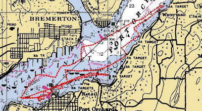
This is the course for the day. We started near the docks at the bottom and northeast toward the radar target at Waterman. Than south west to a turning mark at Ross Point. From there back to the start finish and onto a radar target north of Retsil, back to the mark at Ross point and finish. Our beat to Waterman does not look much different than our run. We were sailing hot angles downwind to keep our speed up. We stayed on the east shore on the beat to try to escape the flooding current and worked toward the Bremerton side on the run to try to take advantage of the flood.

Sunday, March 21, 2010

Gig Harbor Islands Race and Cruise

Saturday was the final race of the South Sound Sailing Series, the Gig Harbor Islands Race. This is a race from Gig Harbor, north through Colvos Pass to a buoy on the north side of Blake Island and return south through Colvos Pass to the finish. The race distance is 29.5NM.

But before we could race, the boat needed to be delivered to Gig Harbor. And here is where the contradiction occurs. Some people have labeled me as a "racer". But even though I race my boat more times than I cruise, I actually do both. And therefore I accept the title of "Sailor". So with this title, I started for Gig Harbor on Thursday morning and made a "cruising" stop at the state park of Blake Island.

I got a late start on Thursday. I had to buy fuel and there was a large powerboat buying several hundred gallons. So I waited. I finally got out of there at around 1100. The wind was up to about 20 knots and I had a great, fast sail to Blake Island. With the wind blowing, docking was tricky, but I docked without embarrassing myself. The moorage was actually quite full for a mid week day. Don't these people work?

I enjoy Blake Island. I walked the 4 miles around the island, spotted a few deer and took a few photos. The sun was out, but with the north wind blowing, it was cool.

After a pleasant night, I left Blake Island at about 0800 and had a great sail south through Colvos Pass to Gig Harbor. The wind was still strong from the north and since I was still in cruising mode, I set only the #3 jib. Even with this small jib, I was sailing at 6-7knots. With the autopilot sailing the boat and the cool sunny weather, it was nice.

The public dock at Jerisch Park was already crowded when I arrived at 1130. I managed to get to the dock on the north side of the dock where rafting is banned. Through the day, boats arrived for the race and rafted up as much as 5 deep. I spent the day kibitzing with other sailors, working on small projects and setting in the sun reading.

Saturday morning, the wind was gone. When we arrived at the start, the wind was light from the SW. The race committee started the races on time, but when our start occurred, the wind had lightened more and with the current flowing north, several boats were over early and some jammed up against the committee boat. So, a general recall was called and our entire class had to restart after the last class. I was probably not over the line, but we were nearly sailing the opposite direction to avoid being swept across the starting line.

When we finally got started, I timed it perfectly and started right on time and pointed the right direction. We set the spinnaker and started the run up Colvos Pass. We had a good run and did well jibing on the shifts and playing the currents. We rounded the mark at Blake Island and started the beat back. We aggressively short tacked along the shore to avoid the always flowing north current of Colvos Pass. We went into shore as close as we dared before tacking out. I counted about 67 tacks. Some boats went a little too close and ran aground. Most were able to get off, but I know at least one that had to use their motor and retire from the race.

When we got to Olalla, the wind died and we caught up to the leaders. We stayed on the west shore. Some boats went to the east shore, but by the time everyone reached Pt Richmond, the wind died again and the boats all got together.

We could see wind ahead and when it reached us, it was intense! The wind increased to 15 knots within seconds and would gust strongly to 20 knots knock us over and then back off to 10 knots every 20-30 seconds. We feathered the boat into the gusts and even though we were slower, we covered the remaining few miles safely and finished at 1757.

Our placing was 8th out of 12 entries. Not a great showing, but it was a spectacular day (until the weather front came through) of sailing. And we did not break anything.

Thanks to the crew of Jim, Peg, Kathleen and Walter for all their hard work.

We took the boat into Gig Harbor, folded sails, unloaded crew and I was back underway at 1848 arriving at Brownsville at 2215. It was a cool, windy evening and rained some.

Total distance covered for the race/cruise was 90.3 NM. Of those miles, probably 65 Nm were sailed. And only 25 were with the motor.
Results can be found at: http://www.ssseries.org/ris.htm

Sea lions like to haul themselves out on the navigation buoys.

Beach at the west end of Blake Island and the Olympic Mountains beyond.

Beach at the west end of Blake Island.

Tillicum Village on Blake Island. In the summer, tour boats bring tourists from Seattle here for a show and dinner.

The moorage at Blake Island.

The easy sail down Colvos Pass.

Boats rafted at Jerisch Park, Gig Harbor.

Our course for the day. We went north up the middle of Colvos Pass and returned down the Kitsap shore.

Saturday, March 13, 2010

Seattle Bicycle Expo

Oh, the horror! A sunny, windy day and I am not sailing my boat. The horror! Two weeks in a row that I have not taken my boat away from the dock. Well, I was in Hawaii last week that is a good excuse. And today was a good day to go to the Seattle Bicycle Expo. It is suppose to be the largest in the country. After moving to various venues around the Seattle area, this year it was at the Pier 91 Cruise ship terminal at the north end of Elliott Bay near Magnolia.


Of course, if you are going to a bicycle show, you really should arrive by bicycle. So, I caught the 0720 ferry and rode the bicycle along the Seattle waterfront and the bike path through Myrtle Edwards park to the expo. The last surprise was that I had to ride past the terminal area a couple of miles and return on another path that went to the pier where the terminal is located. It was not explained very well in the directions.

I arrived early for the 0900 opening. The expo did have lots to see. There were lots of new bikes and components to look at. There were also good sales on clothing and shoes. I found a great pair of cycling shoes at 50% off. They were exactly what I was looking for and what I had hoped to find. A lot of the booths were occupied by groups selling tours or promoting organized rides. I picked up some brochures for some rides and also collected maps from various routes and trails in the northwest. I did not stay very long or watch any demos or presentations. I returned into the wind to the ferry and home. It was farther than I thought it would be: 17.9 miles total.

Now what am I going to do about not sailing this weekend? Nothing, I don't sail every week, too many other fun things to do!
Bicycles, components, clothing, tours and people, people, people!
People looking at the wooden bicycles. Yes, bicycle frames made of wood. Very attractive, light and as stiff as modern materials.

A few others rode their bicycles to the Expo.

Wednesday, March 10, 2010

Back from Hawaii-Mission Accomplished, Now What?

I returned from Hawaii yesterday. The returning flights were good, nobody in the seat next to me on either the Kona/San Francisco or San Francisco/SEATAC legs. I was able to sleep some and the SEATAC flight arrived 20 minutes early. I was able get rapidly to the train. When I called my folks who were going to pick me up from the ferry, I found out that one ferry was broken and fortunatly I was able to catch the 1000 ferry since I was early.

So what's next? First, the bicyle expo on Saturday in Seattle, then boat races on Mar 20 and 27. Maybe see if the Hurricane Ridge road is open yet to go skiing there. I have a meeting in Bellingham and depending on the weekend, I make take the boat and cruise through Friday Harbor and the San Juans on my way there. If the meeting weekend does not work out, I may plan a cruise to Friday Harbor and the San Juans anyway. I was there several times last year, but have not made it to Friday Harbor in the early spring. Would be a great time to take the bicycle and ride the island again. Would like to take a short cruise to Blake Island this spring too. I know, not far but a good outing and going in the middle of the week is a good time to avoid the crowds. I may not go someplace in the boat every week, but I do put a lot of miles on it!

Sunday, March 7, 2010

Hawaii Vacation- Day 5- Kohala District

Today I took a drive to the Kohalo District which is at the most northern tip of Hawaii. The road runs along the shoreline and from the north end of the island, the island of Maul can be seen.

I drove to the end of the road at Pololu where there is a lookout over the valley and the beach below. I hiked down the trail to the beach below, walked the beach and then climbed the 400 feet back up to the parking lot.

I drove across the Kohala Mountains which are the remains of the oldest volcano on the island. The area is mainly grasslands with many ranches. It is also arid enough that cactus grows here.

Returned to the hotel just before the skies opened and it rained for an hour.

Tomorrow I head home, but my flight does not leave until 2150, arrives in San Francisco early on tuesday.

Shoreline at Lapakahi State Historical Park

Lapakahi State Historical Park

Statue of King Kamehameha

Pololu Valley

Beach at Pololu Valley

View from Pololu Valley Lookout

Cactus on Kohala Mountains

Saturday, March 6, 2010

Hawaii Vacation- Day 4- Dormant Volcanoes

Today was another long day of driving. I left early drove back up Saddle Road between Mauna Kea and Mauna Loa. This time I took the road to the weather observatory on Mauna Loa. It is located at an elevation of 11150 feet. The road is one lane and paved, but being paved is a vague definition. It is very rough and full of potholes over most of the distance. It is about 16 miles to the weather observatory which is also the trailhead for a 3.8 mile hike to the crater.

I returned back to the Saddle Road and then went back up to the Mauna Kea Visitors Info Center. I joined the caravan to the summit that was lead by an astronomer. This tour was very informative as we first saw a video on the history of the observatories and then on the summit, our guide gave us good info on the various observatories on the summit. After he left us, I hiked the short distance to the true summit of the mountain. I was surprised that the climb did not leave me gasping for air!

It was rainy farther down the mountain and dark by the time I got back to Kona.


Looking at the observatories of Mauna Kea from Mauna Loa.
The weather observatory on Mauna Loa.

The drive through the lava fields of Mauna Loa.

More lava on Mauna Loa.

Visitors information at 9200 feet on Mauna Kea.

The observatories on Mauna Kea from the summit.

The true summit of Mauna Kea.

Summit of Mauna Kea.

Friday, March 5, 2010

Hawaii Vacation- Day 3- Volcanoes

Today was the drive to the Hawaii Volcanoes National Park. The drive was 96 miles each way and I didn't think I would ever get there!

The park was really impressive. The steam was issuing from Kilauea Caldera, so part of the rim road was closed. Still could see a lot of the Caldera.

I went through the Thurston Lava Tube. It was a bit of a disappointment since the floor was smoothed and lights installed. Not at all like the Ape Caves in Washington State. And it was filled with tourists! The buses bring in sixty at a time.

I drove on the Chain of Craters Road to the shoreline. This road winds through many smaller craters and some of the newer lava flows from the seventies. The road ends where it was covered by a lava flow in 1987.

I returned to Kilauea Iki Crater. I decided to hike a four mile loop that would take me down 400feet to the floor of the crater, across the floor of the crater, back up to the rim and to the car. It was a great hike. After getting through the rough "aa" lava along the edge of the crater, the floor was smooth and hard. There was some steam still issue from small vents in the floor.

Many more pictures on my Facebook page.

Tomorrow I plan to return to Mauna Kea for a guided tour of the observatories. I also am planning on driving up Mauna Loa also.


Breakfast with fresh air and a view.

The southern coast of Hawaii.

Steam vent in Kilauea Caldera.

Kilauea Iki Crater. I hiked the route across the bottom.
The end of the road!


I guess the road is closed!


Holei Sea Arch.

Hiking across the floor of Kilauea Iki Crater.

Thursday, March 4, 2010

Hawaii Vacation-Days 1 and 2

I successfully made my journey to the Island of Hawaii in the county of Hawaii in the state of Hawaii.

I caught the 0720 ferry to Seattle and rode the new light rail to Seatac airport. The train worked really well. I had pre-checked in for the flight from home and it took me two minutes to get through security, so I had plenty of time for breakfast. The flights were good and on time. I checked in to the hotel and had a good night sleep.

This morning I was underway early and drove to the rainy, windward side. I noticed the big difference from the dry leeward side to the rainy, wet windward side. The vegetation on the leeward side is dry and desert like and the windward side is like lush jungle.

I drove to the Waipio Valley lookout, but did not drive down into the valley. Four wheel drive is required(which I have), but I wasn't sure what there was to see. I may go back. I then drove south toward Hilo, stopping at Akaka Falls and driving the "four mile scenic route". I stopped in Hilo and wandered through the farmers market and the shops along the waterfront.

I continued toward Kona over the Saddle Road. This road goes between Mauna Kea and Mauna Loa. It was being worked on and several miles were torn up. Since it was early, I decided to drive up Mauna Kea today. What an experience! The summit is 13796 ft above sea level and was above the rainy clouds. The Keck I viewing gallery was open, so I went inside for a look at the telescope. The gravel road was nowhere as severe as I was led to believe it would be. I will probably go for the guided tour on Saturday.

I got back to the hotel at about 1900. The good thing about where I am staying is that it is right on Alii Drive in the midst of the shops and restaurants.

Tomorrow will be the visit to the Kilauea volcano.

From the lookout above Waipio Valley.
Akaka Falls

Shoreline north of Hilo


The dusty drive up the gravel section.
Observatories on the summit of Mauna Kea.

13680 feet above sea level.


Inside the dome of Keck I looking up at the bottom of the 33ft mirror.

Tuesday, March 2, 2010

Off to Hawaii

In the morning I am heading off to Hawaii. Early morning ferry to Seattle, train to SeaTac, flight to San Francisco and then a final flight to Kona on the Big Island of Hawaii. I am all packed and ready to go. I cashed in some of my frequent flier miles for the flight, have reservations at a cheap hotel in Kona and have reserved a Jeep to get around.

So what are my plans? No.1 plan is to drive to the summit of Mauna Kea, the highest mountain on the island. If the roads are open, and I can plan it right on Saturday, there should be a caravan from the visitors center that will drive to the summit. They will also could allow access to one of the observatories on the summit.

My No.2 plan is to visit the national park at Kilauea. I have always wanted to see the lava fields and caldera. I have researched several short hikes to take.

The rest of my time I want to drive around the island, hike into some waterfalls, visit the historical parks, visit Hilo and just play tourist.

Just flying again will be fun and going through San Francisco airport is usually enjoyable. I have not flown for about 1-1/2 years. I don't mind flying long distances and this is nowhere near as long as I used to fly!

I intend to take a lot of pictures to prove I was there and will post some here and more on my Facebook page. I should return the night of March 8, but will probably post while I am gone.